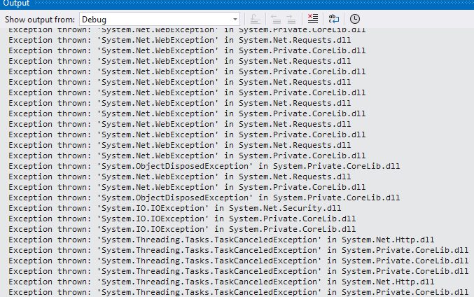
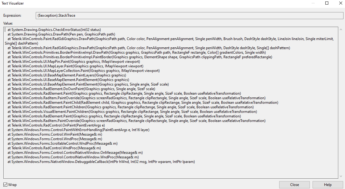
In this scenario, the reported behavior is observed in NET 8. The same behavior is not reproducible in .Net Framework 4.8. When the map is zoomed max out and we try to pan the view, missing tiles appear and the performance is very slow. Additionally, in the output tab of VS, we can observe some exceptions:
In this case, we have missing image tiles while zooming and scrolling the map. When downloading a tile, the internal WebClient is returning an error with the following message: The server committed a protocol violation. Section=ResponseStatusLine. The WebException does not have a Response. This scenario is not handled in code which will lead to missing image tiles. Zooming the same area will reload the missing tiles, but still, it should be handled in the source code.
To reproduce:
- Create a shape with QGIS and add it to RadMap using the approach described in the documentation: http://docs.telerik.com/devtools/winforms/map/file-readers/esri-shapefile-reader
Hi
We would like to use vector tiles in our offline mapping applications, like ones you can get here :- https://openmaptiles.com/downloads/dataset/osm/europe/great-britain/england/#5.03/52.946/-2.426
I think telerik only supports raster files right now. Is there any plans to support vector files in the future? Could it be added to the roadmap?
(I am not looking for a way to convert vector files into PNG/Bitmap/JPEG Image tiles in a custom provider thanks)
Please refer to the attached gif file. The sample project together with the sample files of the local provider can be downloaded here: https://1drv.ms/u/s!AnnV2HsINMD_yxDEY2iOWHXn5V9_?e=VurA0N
There is a noticeable delay after moving the mouse while panning the map. After making a comparison with Open Street Maps and a local provider, it seems that the local provider is slightly slower than the OSM provider. Please refer to the attached gif file.
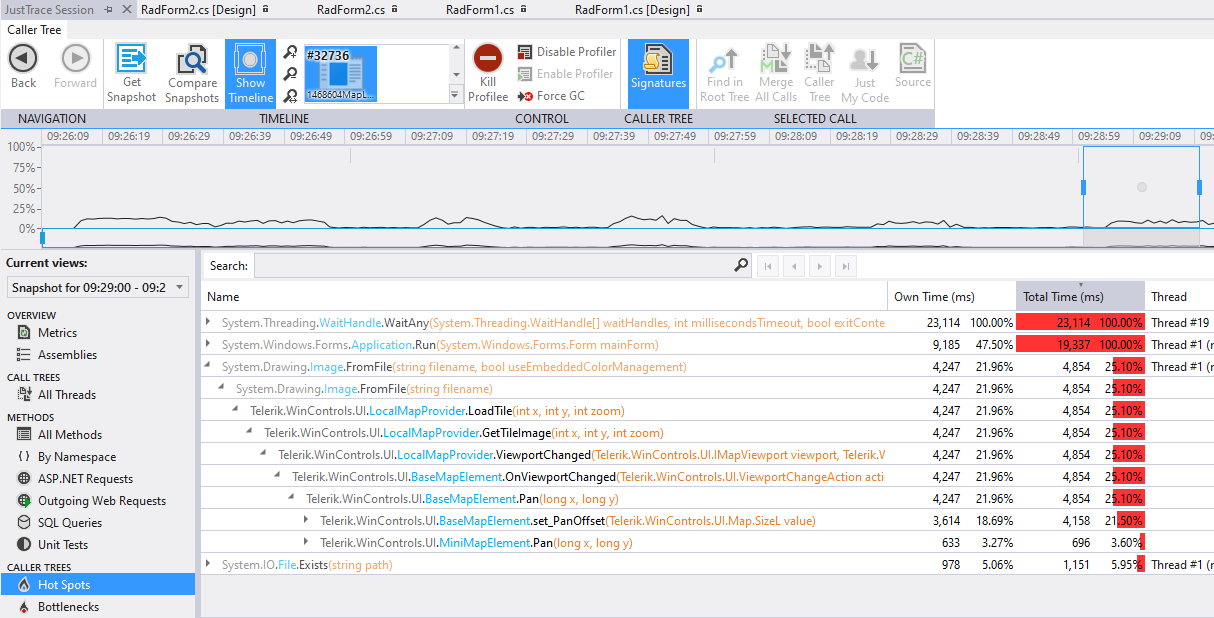
After profiling the project, it seems that Image.FromFile for loading the required tile takes most of the time:
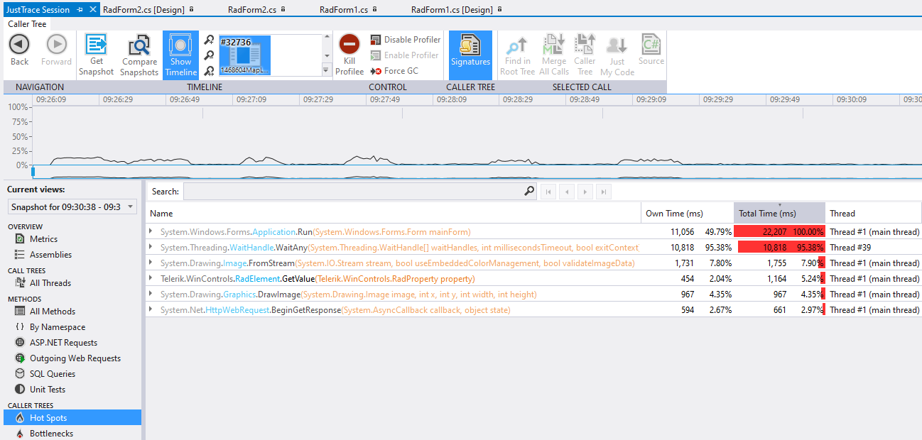
With the OSM the tile is loaded by using Image.FromStream and it takes 3 times less time:
An exception is thrown.
public partial class RadForm1 : RadForm
{
    private BingRestMapProvider bingProvider;

    public RadForm1()
    {
        this.InitializeComponent();
        this.SetupBingProvider();
        this.SetupLayers();

        this.ImportTestItem();
        this.radMapViewer.MapElement.MiniMapElement.EnableZooming = true;
    }

    private void SetupBingProvider()
    {
        string bingKey = "Your Bing Key";

        this.bingProvider = new BingRestMapProvider();
        this.bingProvider.UseSession = true;
        this.bingProvider.BingKey = bingKey;
        this.bingProvider.ImagerySet = Telerik.WinControls.UI.Map.Bing.ImagerySet.Aerial;
        LocalFileCacheProvider cache = new LocalFileCacheProvider(@"..\..\cache");
        this.bingProvider.CacheProvider = cache;
        this.bingProvider.ProviderUpdated += this.BingProvider_ProviderUpdated;
        this.radMapViewer.Providers.Add(this.bingProvider);

        this.bingProvider.InitializationComplete += this.BingProvider_InitializationComplete;
    }

    private void BingProvider_ProviderUpdated(object sender, EventArgs e)
    {
        // Workaround
        this.bingProvider.MaxZoomLevel = 20;
    }

    private void BingProvider_InitializationComplete(object sender, EventArgs e)
    {
        this.radMapViewer.BringIntoView(new PointG(42.698559196991135, 23.320803862212352), 20);
    }

    private void SetupLayers()
    {
        MapLayer modelLayer = new MapLayer("Models");
        this.radMapViewer.Layers.Add(modelLayer);
    }

    public void ImportTestItem()
    {
        Collection<Collection<PointG>> paths = new Collection<Collection<PointG>>();
        var points = new Collection<PointG>();
        paths.Add(points);
        points.Add(new PointG(42.698559196991135, 23.320803862212352));
        points.Add(new PointG(42.698927962901238, 23.319237221916447));
        points.Add(new PointG(42.698928093965123, 23.319236667248555));
        points.Add(new PointG(42.698928095639218, 23.319236660952237));
        points.Add(new PointG(42.698661960692946, 23.319152714625682));
        points.Add(new PointG(42.698661958997257, 23.319152719880927));
        points.Add(new PointG(42.698661126454983, 23.319156258531189));
        points.Add(new PointG(42.698366706433447, 23.320407248233786));
        points.Add(new PointG(42.698559196991135, 23.320803862212352));

        MapPath mapVisual = new MapPath(paths);
        mapVisual.BorderColor = Color.Blue;
        mapVisual.BackColor = Color.Empty;
        mapVisual.BorderWidth = 3;

        this.radMapViewer.Layers["Models"].Add(mapVisual);
    }
}
Hi Team,
Are there any intermediate zoomlevel in the RadMap object?
Currently the transition from one zoomlevel to another is too important.
Thank you for your response
I am wanting to load an image and polygon onto the Map control. I am using a KML file. I am able to load the polygon but NOT able to display the image in the map control.
i.e. if I open the KML file in google earth the image and polygon are displayed, I want to 'replicate' this in the Map control.
Below is my sample code and attached are the KML file and image files.
Dim osmProvider As New OpenStreetMapProvider()
Me.RadMap1.MapElement.Providers.Add(osmProvider)
Me.RadMap1.Layers.Clear()
Me.RadMap1.Layers.Add(New MapLayer("Pens"))
Using seatsStream As New FileStream("D:\MyTelerikMap\Farm.kml", FileMode.Open, FileAccess.Read)
Dim elements As List(Of MapVisualElement) = KmlReader.Read(seatsStream)
For Each item As MapVisualElement In elements
item.BorderWidth = 1
item.BorderColor = Color.Black
item.BackColor = Color.Red
Next
Me.RadMap1.Layers("Pens").AddRange(elements)
End Using
Dim MyCenter As PointG
MyCenter.Latitude = -16.545276685809551
MyCenter.Longitude = 28.87446081916244
RadMap1.MapElement.BringIntoView(MyCenter, 16)
Thank you in advanced for your assistance.
How to reproduce: Check the attached project and video

Workaround: force an update in the MapElement
Public Class RadForm1

    Private bingKey As String = ""
    Dim myTimer As Timer
    Public Sub New()

        InitializeComponent()
        Dim bingProvider As BingRestMapProvider = New Telerik.WinControls.UI.BingRestMapProvider()
        bingProvider.UseSession = True
        bingProvider.BingKey = bingKey

        AddHandler bingProvider.SearchCompleted, AddressOf bingProvider_SearchCompleted

        Me.RadMap1.Providers.Add(bingProvider)

        myTimer = New Timer
        myTimer.Interval = 500
        AddHandler myTimer.Tick, AddressOf OnMyyTimerTick
    End Sub

    Private Function OnMyyTimerTick() As Object
        myTimer.Stop()
        Me.RadMap1.MapElement.InvalidateMeasure(True)
    End Function

    Private Sub bingProvider_SearchCompleted(sender As Object, e As SearchCompletedEventArgs)

        myTimer.Start()

    End Sub
End Class
In WPF this is possible with custom provider: https://www.telerik.com/forums/map-control-and-web-map-service
Error:

System.ArgumentException was unhandled
  HResult=-2147024809
  Message=An item with the same key has already been added.
  Source=mscorlib
  StackTrace:
       at System.ThrowHelper.ThrowArgumentException(ExceptionResource resource)
       at System.Collections.Generic.Dictionary`2.Insert(TKey key, TValue value, Boolean add)
       at Telerik.WinControls.UI.DbfHeader.CreateExtendedPropertySet()
       at Telerik.WinControls.UI.DbfReader..ctor(Stream stream, ExtendedPropertySet propertySet, Encoding encoding)
       at Telerik.WinControls.UI.ShapeFileReader.Read(ShapeFileReaderParameters parameters)
       at _1125357MapShapeFiles.RadForm1..ctor() in d:\Projects\1125357MapShapeFiles\RadForm1.cs:line 37
       at _1125357MapShapeFiles.Program.Main() in d:\Projects\1125357MapShapeFiles\Program.cs:line 17
       at System.AppDomain._nExecuteAssembly(RuntimeAssembly assembly, String[] args)
       at System.AppDomain.ExecuteAssembly(String assemblyFile, Evidence assemblySecurity, String[] args)
       at Microsoft.VisualStudio.HostingProcess.HostProc.RunUsersAssembly()
       at System.Threading.ThreadHelper.ThreadStart_Context(Object state)
       at System.Threading.ExecutionContext.RunInternal(ExecutionContext executionContext, ContextCallback callback, Object state, Boolean preserveSyncCtx)
       at System.Threading.ExecutionContext.Run(ExecutionContext executionContext, ContextCallback callback, Object state, Boolean preserveSyncCtx)
       at System.Threading.ExecutionContext.Run(ExecutionContext executionContext, ContextCallback callback, Object state)
       at System.Threading.ThreadHelper.ThreadStart()
  InnerException:


