When Windows 11 Dark themes are applied the Legend items panel back color is not changed. This behavior is observed in the following themes:
- Windows11Compact11Dark
- Windows11Dark
- Windows11HighContrast
The ShapeFileReader fails in its ReadDbfRecord method:
            using (MemoryStream shapeStream = new MemoryStream(File.ReadAllBytes(@"C:\Users\dyordano\Downloads\84aa4699-f436-4b7e-b029-e353fdab0411_shapefile-before-modification\asseuappareil.shp")))
            {
                using (MemoryStream dbfStream = new MemoryStream(File.ReadAllBytes(@"C:\Users\dyordano\Downloads\84aa4699-f436-4b7e-b029-e353fdab0411_shapefile-before-modification\asseuappareil.dbf")))
                {
                    ShapeFileReaderParameters parameters = new ShapeFileReaderParameters();
                    parameters.ShapeStream = shapeStream;
                    parameters.DbfStream = dbfStream;
                    ShapeFileReader reader = new ShapeFileReader();
                    List<MapVisualElement> elements = reader.Read(parameters);
                }
            }

- HitTest(PointG location)
- HitTest(PointL point)
- HitTest(Point location)
However, if the layer is not visible, its IsVisible property is set to false, the HitTest(PointL point) will not return the clicked pin, but the HitTest(PointG point) method will return it. This behavior is not consistent and all overloads should consider whether the layer is visible or not.
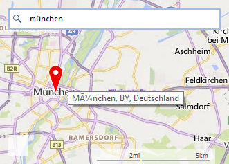
Hello,
on a german Windows, when searching with the bingmapsprovider for "München",
the tooltip on the Pin doesn't shows the ü in the correct way.
So it might be useful if PointG (and PointL, RectangleG, RectangleL, SizeG, SizeL) value types also implement it. There are so many articles about its advantage. The reason is I want to use LINQ queries on a PointG collection, GroupBy, Distinct, etc... so it will be better optimized.
Please refer.
https://medium.com/@semuserable/c-journey-into-struct-equality-comparison-deep-dive-9693f74562f1
The Epilogue part specifically.
Hi,
An exception is thrown while adding layers without name. (System.InvalidOperationException: 'A layer with the same Name already exists in the collection.')
i.e
var layer1 = new MapLayer();
var layer2 = new MapLayer();
map.Layers.Add(layer1);
map.Layers.Add(layer2);
The simple fix is to always pass a unique name, but it must work like say DataTable.Columns.Add(); (which internally generates unique name)
Thanks
Hi,
Please refer attached screen.
In a specific use case, it was required to add MapPins to a MapLayer, and later MapLayer to be added to a RadMap, and this exception.
Thanks
Use the custom implementation in the following KB article: https://docs.telerik.com/devtools/winforms/knowledge-base/radmap-export-to-an-image?_ga=2.41263138.1402359144.1621138970-937174403.1607349180
The pins are successfully exported in version 2021.1.204:
After upgrading to version 2021.2.511, the pins are not exported anymore:

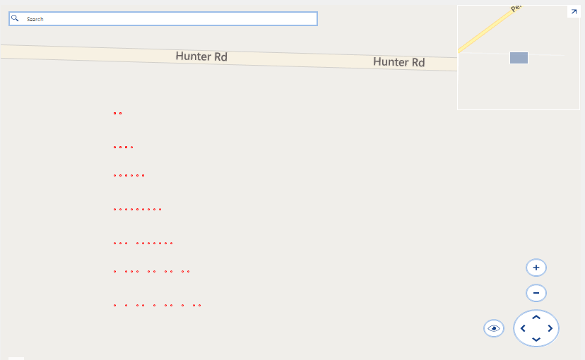
Run the attached project.
Expected:
10 points on each row.
Actual:
There is a seemingly random number of points on each row:
Hello,
I am using RadMap to display a KML file.
Unfortunately, it looks like RadMap is not displaying properly all the shapes (departments).
Displayed with RadMap (few holes, ie departments not displayed):
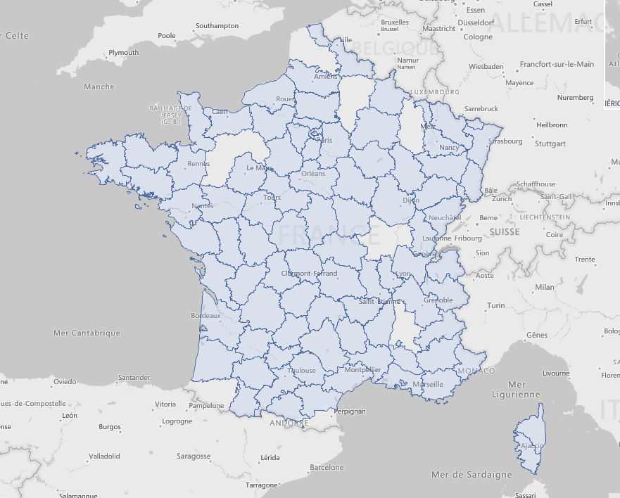
Displayed with a third party tool (all departments properly displayed):
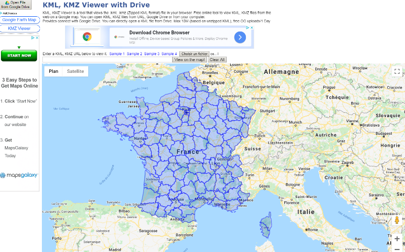
I have attached the KML file in a zip file.
Best,
Olivier
To reproduce: add a RadMap with a Bing provider, select the canvas "Aerial with labels on demand" and zoom in all the way. It always gets the following exception:

System.ArgumentException: Parameter is not valid.
   at System.Drawing.Image.FromStream(Stream stream, Boolean useEmbeddedColorManagement, Boolean validateImageData)
   at Telerik.WinControls.UI.MapTileDownloader.TileDownloadDataCompleted(Object sender, DownloadDataCompletedEventArgs e)
   at System.Net.WebClient.OnDownloadDataCompleted(DownloadDataCompletedEventArgs e)

The issue is reproducible in Demo application with the Bing examples.

Workaround:

        public RadForm1()
        {
            InitializeComponent();

            string cacheFolder = @"..\..\cache";
            BingRestMapProvider bingProvider = new Telerik.WinControls.UI.BingRestMapProvider();
            bingProvider.TileDownloader = new CustomMapTileDownloader();
            bingProvider.UseSession = true;
            bingProvider.BingKey = "your bing key";
            LocalFileCacheProvider cache = new LocalFileCacheProvider(cacheFolder);
            bingProvider.CacheProvider = cache;
            this.radMap1.Providers.Add(bingProvider);

        }

        public class CustomMapTileDownloader : MapTileDownloader
        {
            protected override void TileDownloadDataCompleted(object sender, System.Net.DownloadDataCompletedEventArgs e)
            {
                TileInfo tileInfo = ((TileInfo)e.UserState);

                if (e.Error == null)
                {
                    try
                    {
                        using (MemoryStream ms = new MemoryStream(e.Result))
                        {
                            Image img = Image.FromStream(ms, true, true);
                            tileInfo.Content = e.Result;

                            this.OnTileDownloadComplete(new TileInfoEventArgs(tileInfo));

                            lock (this.webClientsPoolLockObject)
                            {
                                this.webClientsPool[tileInfo.Quadkey].DownloadDataCompleted -= this.TileDownloadDataCompleted;
                                this.webClientsPool.Remove(tileInfo.Quadkey);
                                this.webRequestCache.Remove(tileInfo.Quadkey);
                            }
                        }
                    }
                    catch (Exception)
                    {


                    }


                }
                else
                {
                    if (this.ShouldRetryDownload(e.Error))
                    {
                        Uri uri = this.webRequestCache[tileInfo.Quadkey];

                        lock (this.webClientsPoolLockObject)
                        {
                            uri = new Uri(this.webClientsPool[tileInfo.Quadkey].BaseAddress);
                            this.webClientsPool[tileInfo.Quadkey].DownloadDataCompleted -= this.TileDownloadDataCompleted;
                            this.webClientsPool.Remove(tileInfo.Quadkey);
                            this.webRequestCache.Remove(tileInfo.Quadkey);
                        }

                        this.BeginDownloadTile(uri, tileInfo);
                    }
                }
            }
        }
    }
Recently OpenStreetMap changed their tile usage policy and require UserAgent string in the web headers for accessing tile.openstreetmap.org tiles.
https://operations.osmfoundation.org/policies/tiles/
As a result, standard open street map mode does not work - no tiles are loaded and "too many requests" error is returned from the server.
RadMap's OpenStreetMapProvider needs API (event, property or similar) for easier set up of UserAgent / Referer / other headers of web requests.
I have noticed in the routing there is no maxSolutions parameter available when querying the bing map api routing parameter.
https://docs.microsoft.com/en-us/bingmaps/rest-services/routes/calculate-a-route