Unplanned
Last Updated:
17 Apr 2024 14:35
by ADMIN
ADMIN
Created by:
Dimitar
Comments:
2
Category:
Map
Type:
Bug Report
To reproduce:
- Create a shape with QGIS and add it to RadMap using the approach described in the documentation: http://docs.telerik.com/devtools/winforms/map/file-readers/esri-shapefile-reader
Unplanned
Last Updated:
20 Nov 2017 15:52
by ADMIN
ADMIN
Created by:
Dess | Tech Support Engineer, Principal
Comments:
0
Category:
Map
Type:
Bug Report
Unplanned
Last Updated:
12 Jul 2018 12:50
by ADMIN
ADMIN
Created by:
Hristo
Comments:
0
Category:
Map
Type:
Bug Report
How to reproduce: Check the attached project and video

Workaround: force an update in the MapElement
Public Class RadForm1

    Private bingKey As String = ""
    Dim myTimer As Timer
    Public Sub New()

        InitializeComponent()
        Dim bingProvider As BingRestMapProvider = New Telerik.WinControls.UI.BingRestMapProvider()
        bingProvider.UseSession = True
        bingProvider.BingKey = bingKey

        AddHandler bingProvider.SearchCompleted, AddressOf bingProvider_SearchCompleted

        Me.RadMap1.Providers.Add(bingProvider)

        myTimer = New Timer
        myTimer.Interval = 500
        AddHandler myTimer.Tick, AddressOf OnMyyTimerTick
    End Sub

    Private Function OnMyyTimerTick() As Object
        myTimer.Stop()
        Me.RadMap1.MapElement.InvalidateMeasure(True)
    End Function

    Private Sub bingProvider_SearchCompleted(sender As Object, e As SearchCompletedEventArgs)

        myTimer.Start()

    End Sub
End Class
Unplanned
Last Updated:
05 Aug 2019 12:03
by ADMIN
Created by:
Ken
Comments:
1
Category:
Map
Type:
Bug Report
Is there a way to not allow the map to WrapAround?
Unplanned
Last Updated:
20 Nov 2017 15:42
by ADMIN
ADMIN
Created by:
Dess | Tech Support Engineer, Principal
Comments:
0
Category:
Map
Type:
Bug Report
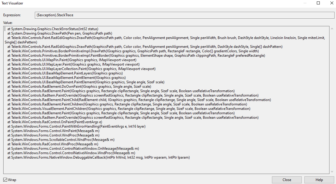
Error:

System.ArgumentException was unhandled
  HResult=-2147024809
  Message=An item with the same key has already been added.
  Source=mscorlib
  StackTrace:
       at System.ThrowHelper.ThrowArgumentException(ExceptionResource resource)
       at System.Collections.Generic.Dictionary`2.Insert(TKey key, TValue value, Boolean add)
       at Telerik.WinControls.UI.DbfHeader.CreateExtendedPropertySet()
       at Telerik.WinControls.UI.DbfReader..ctor(Stream stream, ExtendedPropertySet propertySet, Encoding encoding)
       at Telerik.WinControls.UI.ShapeFileReader.Read(ShapeFileReaderParameters parameters)
       at _1125357MapShapeFiles.RadForm1..ctor() in d:\Projects\1125357MapShapeFiles\RadForm1.cs:line 37
       at _1125357MapShapeFiles.Program.Main() in d:\Projects\1125357MapShapeFiles\Program.cs:line 17
       at System.AppDomain._nExecuteAssembly(RuntimeAssembly assembly, String[] args)
       at System.AppDomain.ExecuteAssembly(String assemblyFile, Evidence assemblySecurity, String[] args)
       at Microsoft.VisualStudio.HostingProcess.HostProc.RunUsersAssembly()
       at System.Threading.ThreadHelper.ThreadStart_Context(Object state)
       at System.Threading.ExecutionContext.RunInternal(ExecutionContext executionContext, ContextCallback callback, Object state, Boolean preserveSyncCtx)
       at System.Threading.ExecutionContext.Run(ExecutionContext executionContext, ContextCallback callback, Object state, Boolean preserveSyncCtx)
       at System.Threading.ExecutionContext.Run(ExecutionContext executionContext, ContextCallback callback, Object state)
       at System.Threading.ThreadHelper.ThreadStart()
  InnerException:
Unplanned
Last Updated:
04 Mar 2020 15:28
by ADMIN
Created by:
James
Comments:
0
Category:
Map
Type:
Bug Report
Add a MapPath object to a layer of RadMap and zoom in to the last possible level.
An exception is thrown.
An exception is thrown.
public partial class RadForm1 : RadForm
{
    private BingRestMapProvider bingProvider;

    public RadForm1()
    {
        this.InitializeComponent();
        this.SetupBingProvider();
        this.SetupLayers();

        this.ImportTestItem();
        this.radMapViewer.MapElement.MiniMapElement.EnableZooming = true;
    }

    private void SetupBingProvider()
    {
        string bingKey = "Your Bing Key";

        this.bingProvider = new BingRestMapProvider();
        this.bingProvider.UseSession = true;
        this.bingProvider.BingKey = bingKey;
        this.bingProvider.ImagerySet = Telerik.WinControls.UI.Map.Bing.ImagerySet.Aerial;
        LocalFileCacheProvider cache = new LocalFileCacheProvider(@"..\..\cache");
        this.bingProvider.CacheProvider = cache;
        this.bingProvider.ProviderUpdated += this.BingProvider_ProviderUpdated;
        this.radMapViewer.Providers.Add(this.bingProvider);

        this.bingProvider.InitializationComplete += this.BingProvider_InitializationComplete;
    }

    private void BingProvider_ProviderUpdated(object sender, EventArgs e)
    {
        // Workaround
        this.bingProvider.MaxZoomLevel = 20;
    }

    private void BingProvider_InitializationComplete(object sender, EventArgs e)
    {
        this.radMapViewer.BringIntoView(new PointG(42.698559196991135, 23.320803862212352), 20);
    }

    private void SetupLayers()
    {
        MapLayer modelLayer = new MapLayer("Models");
        this.radMapViewer.Layers.Add(modelLayer);
    }

    public void ImportTestItem()
    {
        Collection<Collection<PointG>> paths = new Collection<Collection<PointG>>();
        var points = new Collection<PointG>();
        paths.Add(points);
        points.Add(new PointG(42.698559196991135, 23.320803862212352));
        points.Add(new PointG(42.698927962901238, 23.319237221916447));
        points.Add(new PointG(42.698928093965123, 23.319236667248555));
        points.Add(new PointG(42.698928095639218, 23.319236660952237));
        points.Add(new PointG(42.698661960692946, 23.319152714625682));
        points.Add(new PointG(42.698661958997257, 23.319152719880927));
        points.Add(new PointG(42.698661126454983, 23.319156258531189));
        points.Add(new PointG(42.698366706433447, 23.320407248233786));
        points.Add(new PointG(42.698559196991135, 23.320803862212352));

        MapPath mapVisual = new MapPath(paths);
        mapVisual.BorderColor = Color.Blue;
        mapVisual.BackColor = Color.Empty;
        mapVisual.BorderWidth = 3;

        this.radMapViewer.Layers["Models"].Add(mapVisual);
    }
}
Unplanned
Last Updated:
05 Jun 2020 06:52
by ADMIN
Created by:
Yariv
Comments:
0
Category:
Map
Type:
Bug Report
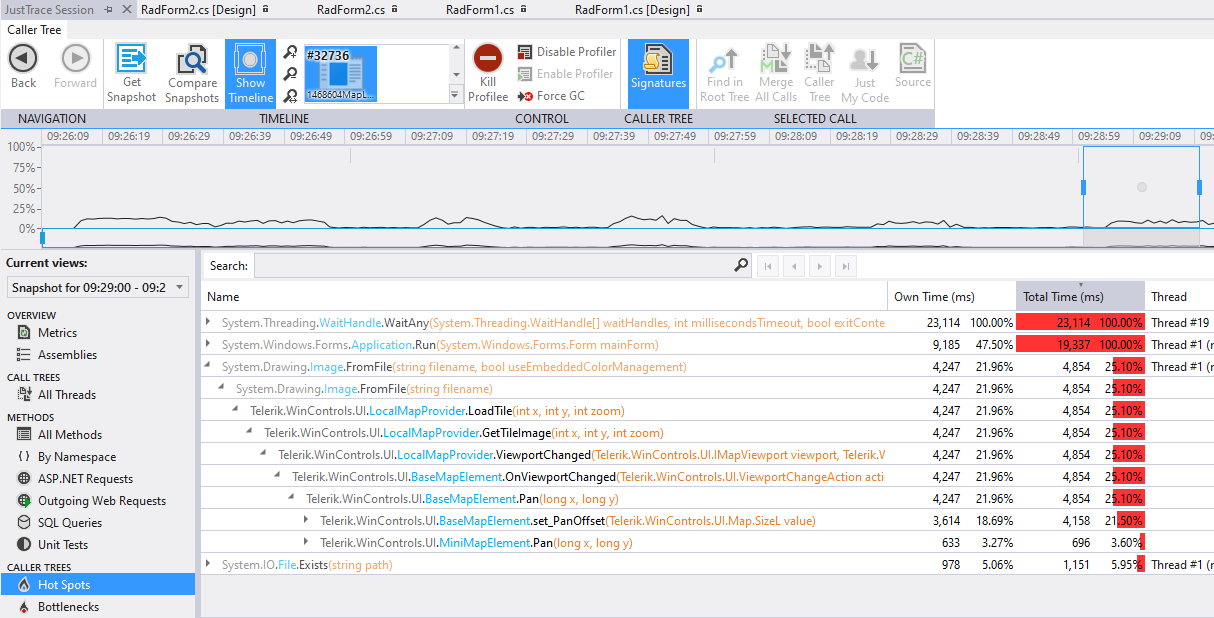
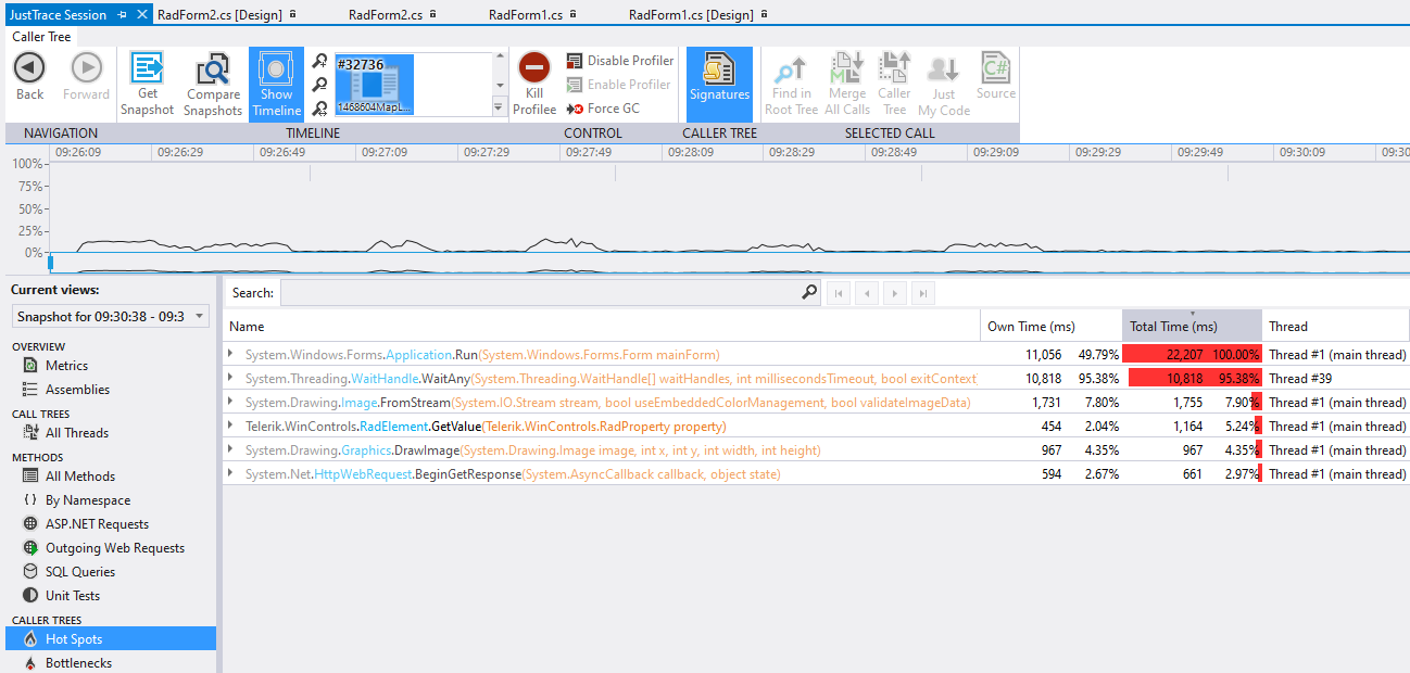
There is a noticeable delay after moving the mouse while panning the map. After making a comparison with Open Street Maps and a local provider, it seems that the local provider is slightly slower than the OSM provider. Please refer to the attached gif file.
After profiling the project, it seems that Image.FromFile for loading the required tile takes most of the time:
With the OSM the tile is loaded by using Image.FromStream and it takes 3 times less time:
Unplanned
Last Updated:
13 Aug 2020 12:02
by ADMIN
Created by:
Max
Comments:
0
Category:
Map
Type:
Bug Report
Please refer to the attached gif file. The sample project together with the sample files of the local provider can be downloaded here: https://1drv.ms/u/s!AnnV2HsINMD_yxDEY2iOWHXn5V9_?e=VurA0N