In the scenario below one should be able to access the defined UserData value in the SearchCompleted event handler

How to reproduce:
protected override void OnLoad(EventArgs e)
        {
            base.OnLoad(e);

            this.radMap1.ShowSearchBar = true;
            BingRestMapProvider bingProvider = this.radMap1.Providers[0] as BingRestMapProvider;
            this.radMap1.MapElement.SearchBarElement.SearchProvider = bingProvider;

            this.radMap1.MapElement.SearchBarElement.SearchProvider.SearchCompleted += BingProvider_SearchCompleted;
        }

        private void BingProvider_SearchCompleted(object sender, SearchCompletedEventArgs e)
        {
            Telerik.WinControls.UI.Map.RectangleG allPoints = new Telerik.WinControls.UI.Map.RectangleG(double.MinValue, double.MaxValue, double.MaxValue, double.MinValue);
            this.radMap1.Layers["Pins"].Clear();
            foreach (Telerik.WinControls.UI.Map.Bing.Location location in e.Locations)
            {
                Telerik.WinControls.UI.Map.PointG point = new Telerik.WinControls.UI.Map.PointG(location.Point.Coordinates[0], location.Point.Coordinates[1]);
                MapPin pin = new MapPin(point);
                pin.Size = new System.Drawing.Size(20, 40);
                pin.BackColor = Color.Red;
                pin.ToolTipText = location.Address.FormattedAddress;
                this.radMap1.MapElement.Layers["Pins"].Add(pin);
                allPoints.North = Math.Max(allPoints.North, point.Latitude);
                allPoints.South = Math.Min(allPoints.South, point.Latitude);
                allPoints.West = Math.Min(allPoints.West, point.Longitude);
                allPoints.East = Math.Max(allPoints.East, point.Longitude);
            }
            if (e.Locations.Length > 0)
            {
                if (e.Locations.Length == 1)
                {
                    this.radMap1.BringIntoView(new Telerik.WinControls.UI.Map.PointG(e.Locations[0].Point.Coordinates[0], e.Locations[0].Point.Coordinates[1]));
                }
                else
                {
                    this.radMap1.MapElement.BringIntoView(allPoints);
                    this.radMap1.Zoom(this.radMap1.MapElement.ZoomLevel - 1);
                }
            }
            else
            {
                RadMessageBox.Show("No result found for the provided search query!");
            }
        }

        Telerik.WinControls.UI.Map.Bing.SearchRequest request;
        private void radButton1_Click(object sender, EventArgs e)
        {
            Telerik.WinControls.UI.MapLayer pinsLayer = new MapLayer("Pins");
            this.radMap1.Layers.Add(pinsLayer);

            request = new SearchRequest();
            request.Query = "San Marino";
            request.SearchOptions.Count = 10;
            request.SearchOptions.QueryParse = true;
            request.UserData = "Tooltip";
            BingRestMapProvider bingProvider = this.radMap1.Providers[0] as BingRestMapProvider;
            bingProvider.SearchAsync(request);
        }

Workaround:  if possible cache the data to be accessed at a later stage
You can find attached a sample project, video, demonstrating the steps and a screenshot of the error.

Workaround:

public class MyMapVisualElementFactory : MapVisualElementFactory
{
    public override MapVisualElement CreatePolyline(Collection<PointG> points)
    {
        return new MyMapPolyline(points);
    }
}

public class MyMapPolyline : MapPolyline
{
    private FieldInfo pathsField;
    private FieldInfo boundingRectsField;
    private FieldInfo isInViewportField;

    public MyMapPolyline(Collection<PointG> points) : base(points)
    {
        this.pathsField = typeof(MapPolyline).GetField("paths", BindingFlags.Instance | BindingFlags.NonPublic);
        this.boundingRectsField = typeof(MapPolyline).GetField("boundingRects", BindingFlags.Instance | BindingFlags.NonPublic);
        this.isInViewportField = typeof(MapPolyline).GetField("isInViewport", BindingFlags.Instance | BindingFlags.NonPublic);
    }

    public override void ViewportChanged(IMapViewport viewport, ViewportChangeAction action)
    {
        if ((action & ViewportChangeAction.All) == action)
        {
            long mapSize = MapTileSystemHelper.MapSize(viewport.ZoomLevel);
            List<GraphicsPath> paths = new List<GraphicsPath>();
            List<RectangleL> boundingRects = new List<RectangleL>();

            long start = viewport.PanOffset.Width;
            int maxWraparounds = 1;

            while (start + mapSize < viewport.ViewportInPixels.Width)
            {
                maxWraparounds++;
                start += mapSize;
            }

            for (int i = -1; i <= maxWraparounds; i++)
            {
                GraphicsPath path = new GraphicsPath();

                List<PointF> drawPoints = new List<PointF>();

                foreach (PointG p in this.Points)
                {
                    PointL pixel = MapTileSystemHelper.LatLongToPixelXY(p.Latitude, p.Longitude, viewport.ZoomLevel);
                    drawPoints.Add(new PointF(pixel.X + i * mapSize, pixel.Y));
                }

                path.AddLines(drawPoints.ToArray());

                RectangleF rect = path.GetBounds();
                RectangleF view = new RectangleF(viewport.ViewportInPixels.X, viewport.ViewportInPixels.Y,
                    viewport.ViewportInPixels.Width, viewport.ViewportInPixels.Height);

                if (rect.IntersectsWith(view))
                {
                    paths.Add(path);
                }

                boundingRects.Add(new RectangleL((long)rect.X, (long)rect.Y, (long)rect.Width, (long)rect.Height));
            }

            this.pathsField.SetValue(this, paths);
            this.boundingRectsField.SetValue(this, boundingRects);
        }

        if (action != ViewportChangeAction.None)
        {
            this.isInViewportField.SetValue(this, false);
            List<RectangleL> boundingRects = this.boundingRectsField.GetValue(this) as List<RectangleL>;

            foreach (RectangleL rect in boundingRects)
            {
                if (viewport.ViewportInPixels.IntersectsWith(rect))
                {
                    this.isInViewportField.SetValue(this, true);
                }
            }
        }
    }
}
Workaround:
Public Class MyLocalMapProvider
    Inherits LocalMapProvider

    Public Overrides Sub ViewportChanged(viewport As IMapViewport, action As ViewportChangeAction)
        If Not Me.Initialized Then
            Me.Initialize()

            Return
        End If

        Dim tilesToDraw As List(Of MapVisualElement) = DirectCast(Me.GetType().BaseType.GetField("tilesToDraw", BindingFlags.Instance Or BindingFlags.NonPublic).GetValue(Me), List(Of MapVisualElement))

        Dim numOfTilesX As Integer = CInt(Math.Ceiling(CDbl((viewport.ViewportInPixels.Width)) / Me.TileSize.Width)) + 2
        Dim numOfTilesY As Integer = CInt(Math.Ceiling(CDbl((viewport.ViewportInPixels.Height)) / Me.TileSize.Height)) + 2
        Dim maxNumberOfTilesY As Integer = If((viewport.ZoomLevel = 1), 2, (viewport.ZoomLevel - 1) << 2)
        numOfTilesY = Math.Min(numOfTilesY, maxNumberOfTilesY)

        Dim topLeftTile As Point = MapTileSystemHelper.PixelXYToTileXY(-viewport.PanOffset.Width, -viewport.PanOffset.Height)

        Dim numberOfTiles As Integer = 2 << (viewport.ZoomLevel - 1)
        Dim startX As Integer = CInt(viewport.PanOffset.Width) Mod Me.TileSize.Width
        Dim startY As Integer = CInt(viewport.PanOffset.Height) Mod Me.TileSize.Height

        If startX > 0 Then
            startX -= Me.TileSize.Width
        End If

        For i As Integer = 0 To numOfTilesY - 1
            For j As Integer = 0 To numOfTilesX - 1
                Dim x As Integer = startX + j * Me.TileSize.Width
                Dim y As Integer = startY + i * Me.TileSize.Height

                Dim tileX As Integer = (topLeftTile.X + j) Mod numberOfTiles
                Dim tileY As Integer = (topLeftTile.Y + i) Mod numberOfTiles

                If tileX < 0 Then
                    tileX += numberOfTiles
                End If

                tilesToDraw.Add(New MapTile(Me.GetTileImage(tileX, tileY, viewport.ZoomLevel), New Rectangle(New Point(x, y), Me.TileSize)))
            Next
        Next
    End Sub
End Class
To reproduce:

        public RadForm1()
        {
            InitializeComponent();

            this.radMap1.ToolTipTextNeeded += radMap1_ToolTipTextNeeded;

            BingRestMapProvider bingProvider = new Telerik.WinControls.UI.BingRestMapProvider();
            bingProvider.UseSession = true;
            bingProvider.BingKey = bingKey;

            this.radMap1.Providers.Add(bingProvider);

            //add a layer to display the route
            this.radMap1.MapElement.Layers.Add(new MapLayer());

            RouteRequest request = new RouteRequest();
            request.DistanceUnit = DistanceUnit.Kilometer;
            request.Options.Mode = TravelMode.Driving;
            request.Options.Optimization = RouteOptimization.Time;
            request.Options.RouteAttributes = RouteAttributes.RoutePath;
            request.Options.RouteAvoidance = RouteAvoidance.None;
            request.Waypoints.Add("Paris, France");
            request.Waypoints.Add("Madrid, Spain");

            bingProvider.CalculateRouteCompleted += BingProvider_RoutingCompleted;
            bingProvider.CalculateRouteAsync(request);
        }

        private void radMap1_ToolTipTextNeeded(object sender, Telerik.WinControls.ToolTipTextNeededEventArgs e)
        {
            Console.WriteLine(sender);
        }

        private void BingProvider_RoutingCompleted(object sender, RoutingCompletedEventArgs e)
        {

            List<PointG> pts = new List<PointG>();
            Telerik.WinControls.UI.Map.PointG startPoint = new Telerik.WinControls.UI.Map.PointG(e.Route.RoutePath.Line.Coordinates.First()[0], e.Route.RoutePath.Line.Coordinates.First()[1]);
            pts.Add(startPoint);
            Telerik.WinControls.UI.Map.PointG endPoint = new Telerik.WinControls.UI.Map.PointG(e.Route.RoutePath.Line.Coordinates.Last()[0], e.Route.RoutePath.Line.Coordinates.Last()[1]);
            pts.Add(endPoint);
            MapPolyline mapPolyline = new MapPolyline(pts);
            mapPolyline.BackColor = Color.Red;
            mapPolyline.BorderColor = Color.Red;
            mapPolyline.BorderWidth = 5;
            this.radMap1.MapElement.Layers[0].Add(mapPolyline);

            PointG midPoint = new PointG((startPoint.Latitude + endPoint.Latitude) / 2d, (startPoint.Longitude + endPoint.Longitude) / 2d);
            MapLabel westernLabel = new MapLabel(midPoint, "My label")
            {
                BackColor = Color.FromArgb(122, 255, 0, 0)
            };
            this.radMap1.MapElement.Layers[0].Add(westernLabel);
        }

Workaround:

        public class CustomMapPolyline : MapPolyline
        {
            List<GraphicsPath> paths;

            public CustomMapPolyline(IEnumerable<PointG> points) : base(points)
            {
            }

            public override void ViewportChanged(IMapViewport viewport, ViewportChangeAction action)
            {
                base.ViewportChanged(viewport, action);

                FieldInfo fi = typeof(MapPolyline).GetField("paths", BindingFlags.Instance | BindingFlags.NonPublic);
                this.paths = (List<GraphicsPath>)fi.GetValue(this);
            }

                     public override bool HitTest(PointG pointG, PointL pointL, IMapViewport viewport)
            {
                using (Pen pen = new Pen(this.BorderColor, this.BorderWidth))
                {
                    foreach (GraphicsPath path in this.paths)
                    {
                        if (path.IsOutlineVisible(pointL.X, pointL.Y, pen))
                        {
                            return true;
                        }
                    }
                }

                return false;
            }
        }
1. Open the demo application >> Map >> Search example.
2. Enter some text and press Enter.
3. Move the mouse a little bit and you will notice the search box looses focus.

Workaround:  this.radMap1.MapElement.SearchBarElement.SearchTextBoxElement.TextBoxItem.LostFocus+=TextBoxItem_LostFocus;

        private void TextBoxItem_LostFocus(object sender, EventArgs e)
        {
            this.radMap1.MapElement.SearchBarElement.SearchTextBoxElement.TextBoxItem.TextBoxControl.Focus();
        }
How to reproduce: check the attached video

Workaround: create a custom MapSearchBarElement
public class MyRadMap : RadMap
{
    public override string ThemeClassName
    {
        get
        {
            return typeof(RadMap).FullName;
        }
    }

    protected override RadMapElement CreateMapElement()
    {
        return new MyRadMapElement();
    }
}

public class MyRadMapElement :  RadMapElement
{
    protected override Type ThemeEffectiveType
    {
        get
        {
            return typeof(RadMapElement);
        }
    }

    protected override MapSearchBarElement CreateSearchBarElement()
    {

        return new MyMapSearchBarElement(this);
    }
}

public class MyMapSearchBarElement : MapSearchBarElement
{
    public MyMapSearchBarElement(MyRadMapElement mapElement)
        : base(mapElement)
    { }

    protected override Type ThemeEffectiveType
    {
        get
        {
            return typeof(MapSearchBarElement);
        }
    }

    protected override void SearchProviderSearchError(object sender, SearchErrorEventArgs e)
    {
        IMapSearchProvider provider = sender as IMapSearchProvider;
        provider.SearchCompleted -= SearchProviderSearchCompleted;
        provider.SearchError -= SearchProviderSearchError;

        if (this.ElementTree != null)
        {
            UnsubscribeToTextBoxEvents(this.SearchTextBoxElement);
            RadMessageBox.SetThemeName(this.ElementTree.ThemeName);
            RadMessageBox.Show(e.Error.Message);
            SubscribeToTextBoxEvents(this.SearchTextBoxElement);
        }
    }

    protected override void SubscribeToTextBoxEvents(RadTextBoxElement textBox)
    {
        textBox.TextChanged += OnSearchTextBoxTextChanged;
        textBox.KeyDown += OnSearchTextBoxKeyDown;
    }

    protected override void UnsubscribeToTextBoxEvents(RadTextBoxElement textBox)
    {
        textBox.TextChanged -= OnSearchTextBoxTextChanged;
        textBox.KeyDown -= OnSearchTextBoxKeyDown;
    }

    private void OnSearchTextBoxKeyDown(object sender, System.Windows.Forms.KeyEventArgs e)
    {
        if (e.KeyCode == Keys.Enter)
        {
            this.Search(this.SearchTextBoxElement.Text);
        }
    }
}
How to reproduce: change the Windows culture to Greek and start the OSM example
How to reproduce:
public partial class Form3 : Form
 {
     public Form3()
     {
         InitializeComponent();

         MapLayer pointLayer = new MapLayer("PointG");
         pointLayer.ClusterStrategy = new ElementClusterStrategy();
         pointLayer.ClusterDistance = 100;
         this.radMap1.Layers.Add(pointLayer);

         MapPin pin1 = new MapPin(new PointG(45d, 15d)) { BackColor = Color.Coral, ToolTipText = "Tool Tip1" };
         MapPin pin2 = new MapPin(new PointG(44d, 18d)) { BackColor = Color.Coral, ToolTipText = "Tool Tip2" };
         this.radMap1.Layers["PointG"].Add(pin1);
         this.radMap1.Layers["PointG"].Add(pin2);

         this.SetupProviders();
     }

     private void radMap1_ToolTipTextNeeded(object sender, Telerik.WinControls.ToolTipTextNeededEventArgs e)
     {
         MapCluster cluster = sender as MapCluster;
         if (cluster != null && cluster.ClusteredItems.Count == 1)
         {
             cluster.ToolTipText = ((MapPin)cluster.ClusteredItems[0]).ToolTipText;
         }
     }

     private void SetupProviders()
     {
         string cacheFolder = @"..\..\cache";
         BingRestMapProvider bingProvider = new BingRestMapProvider();
         bingProvider.Culture = System.Threading.Thread.CurrentThread.CurrentCulture;
         bingProvider.ImagerySet = ImagerySet.Road;
         bingProvider.UseSession = true;
         bingProvider.BingKey = "...";

         LocalFileCacheProvider cache = new LocalFileCacheProvider(cacheFolder);
         bingProvider.CacheProvider = cache;

         this.radMap1.MapElement.Providers.Add(bingProvider);

         bingProvider.InitializationComplete += bingProvider_InitializationComplete;
     }

     private void bingProvider_InitializationComplete(object sender, EventArgs e)
     {
         this.radMap1.BringIntoView(new PointG(45d, 15d), 5);
     }

 }

Workaround: handle the ToolTipNeededEvent
 private void radMap1_ToolTipTextNeeded(object sender, Telerik.WinControls.ToolTipTextNeededEventArgs e)
 {
     MapCluster cluster = sender as MapCluster;
     if (cluster != null && cluster.ClusteredItems.Count == 1)
     {
         cluster.ToolTipText = ((MapPin)cluster.ClusteredItems[0]).ToolTipText;
     }
 }
To reproduce:
set the clustering and add some pins upon a button click.
Workaround
Refresh with the following method:
1. Add a pin to the map.
radMap1.Layers.Add(new MapLayer("PinLayer"));
MapPin pin = new MapPin(new Telerik.WinControls.UI.Map.PointG(47.60357, -122.32945));
pin.BackColor = Color.Red;
radMap1.Layers[0].Add(pin);
2. Run the project and zoom out.
3. Resize vertically the map(form).
Workaround:
Call Pan method to recalculate RadMapElement.ViewportInPixels on SizeChanged.
private void RadMap1_SizeChanged(object sender, EventArgs e)
{
this.radMap1.Pan(this.radMap1.MapElement.PanOffset.Width, this.radMap1.MapElement.PanOffset.Height);
}
Please refer to the sample project and follow the steps:
1. Run the attached application.2. Hover over the calendar (custom cluster)
3. Tooltip is shown.
4. Zoom out once
5. Hover over the calendar.
6. No tooltip is shown - ToolTipTextNeeded is not called.
7. Zoom out once more.
8. Hover over the calendar.
9. No tooltip is shown - ToolTextNeeded is not called.
10. Zoom out once more. Now two icons are shown.
11. Hover over either calendar.
12. Tooltip is shown.
Recently OpenStreetMap changed their tile usage policy and require UserAgent string in the web headers for accessing tile.openstreetmap.org tiles.
https://operations.osmfoundation.org/policies/tiles/
As a result, standard open street map mode does not work - no tiles are loaded and "too many requests" error is returned from the server.
RadMap's OpenStreetMapProvider needs API (event, property or similar) for easier set up of UserAgent / Referer / other headers of web requests.
Hello,
I am using RadMap to display a KML file.
Unfortunately, it looks like RadMap is not displaying properly all the shapes (departments).
Displayed with RadMap (few holes, ie departments not displayed):
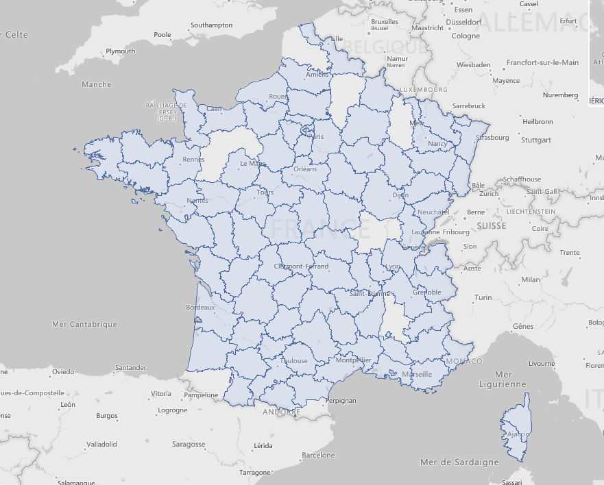
Displayed with a third party tool (all departments properly displayed):
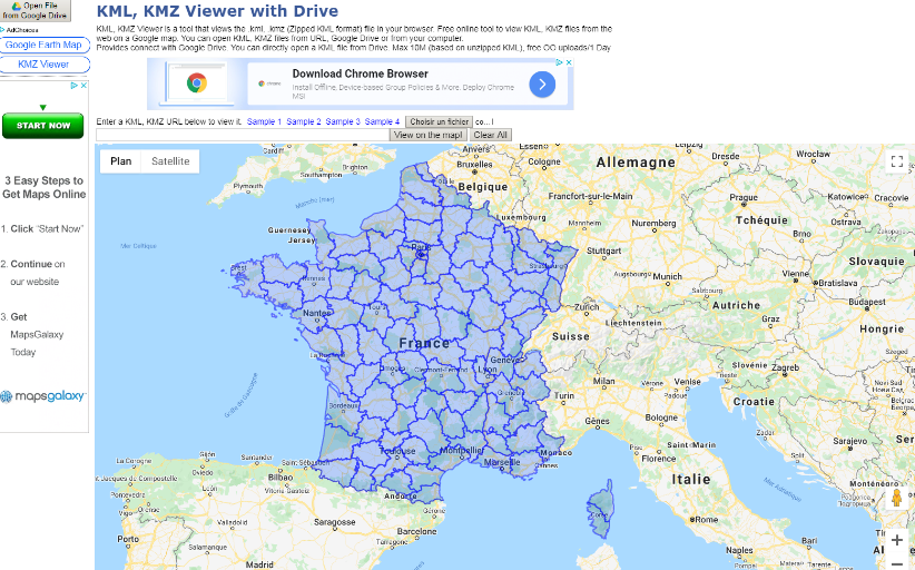
I have attached the KML file in a zip file.
Best,
Olivier
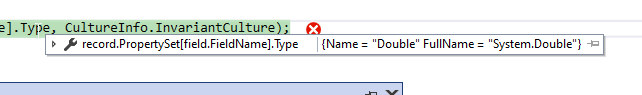
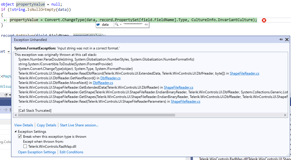
The ShapeFileReader fails in its ReadDbfRecord method:
            using (MemoryStream shapeStream = new MemoryStream(File.ReadAllBytes(@"C:\Users\dyordano\Downloads\84aa4699-f436-4b7e-b029-e353fdab0411_shapefile-before-modification\asseuappareil.shp")))
            {
                using (MemoryStream dbfStream = new MemoryStream(File.ReadAllBytes(@"C:\Users\dyordano\Downloads\84aa4699-f436-4b7e-b029-e353fdab0411_shapefile-before-modification\asseuappareil.dbf")))
                {
                    ShapeFileReaderParameters parameters = new ShapeFileReaderParameters();
                    parameters.ShapeStream = shapeStream;
                    parameters.DbfStream = dbfStream;
                    ShapeFileReader reader = new ShapeFileReader();
                    List<MapVisualElement> elements = reader.Read(parameters);
                }
            }
To reproduce:
- Use a DataTable as a data source for SqlGeospatialDataReader.
- An exception will occur.

Workaround:
Convert the data table to a simple list of custom objects.
How to reproduce: Change the current culture so that a comma is used as a decimal separator, the Elevations example will fail with a (400) Bar Request error.

Workaround: create a custom BingRestMapProvider class
public class CustomBingRestMapProvider : BingRestMapProvider
    {
        protected override string GetPointsString(List<PointG> points)
        {
            StringBuilder sb = new StringBuilder();

            for (int i = 0; i < points.Count; i++)
            {
                PointG point = points[i];

                if (i > 0)
                {
                    sb.Append(",");
                }

                sb.Append(point.Latitude.ToString(CultureInfo.InvariantCulture) + "," + point.Longitude.ToString(CultureInfo.InvariantCulture));
            }

            return sb.ToString();
        }
    }
To reproduce: use the ToolTipTextNeeded event to assign some tool tips for the MapRoutes. You will notice that the tool tips are shown not only when you hover the route line but also around it.
To reproduce: add a RadMap with a Bing provider, select the canvas "Aerial with labels on demand" and zoom in all the way. It always gets the following exception:

System.ArgumentException: Parameter is not valid.
   at System.Drawing.Image.FromStream(Stream stream, Boolean useEmbeddedColorManagement, Boolean validateImageData)
   at Telerik.WinControls.UI.MapTileDownloader.TileDownloadDataCompleted(Object sender, DownloadDataCompletedEventArgs e)
   at System.Net.WebClient.OnDownloadDataCompleted(DownloadDataCompletedEventArgs e)

The issue is reproducible in Demo application with the Bing examples.

Workaround:

        public RadForm1()
        {
            InitializeComponent();

            string cacheFolder = @"..\..\cache";
            BingRestMapProvider bingProvider = new Telerik.WinControls.UI.BingRestMapProvider();
            bingProvider.TileDownloader = new CustomMapTileDownloader();
            bingProvider.UseSession = true;
            bingProvider.BingKey = "your bing key";
            LocalFileCacheProvider cache = new LocalFileCacheProvider(cacheFolder);
            bingProvider.CacheProvider = cache;
            this.radMap1.Providers.Add(bingProvider);

        }

        public class CustomMapTileDownloader : MapTileDownloader
        {
            protected override void TileDownloadDataCompleted(object sender, System.Net.DownloadDataCompletedEventArgs e)
            {
                TileInfo tileInfo = ((TileInfo)e.UserState);

                if (e.Error == null)
                {
                    try
                    {
                        using (MemoryStream ms = new MemoryStream(e.Result))
                        {
                            Image img = Image.FromStream(ms, true, true);
                            tileInfo.Content = e.Result;

                            this.OnTileDownloadComplete(new TileInfoEventArgs(tileInfo));

                            lock (this.webClientsPoolLockObject)
                            {
                                this.webClientsPool[tileInfo.Quadkey].DownloadDataCompleted -= this.TileDownloadDataCompleted;
                                this.webClientsPool.Remove(tileInfo.Quadkey);
                                this.webRequestCache.Remove(tileInfo.Quadkey);
                            }
                        }
                    }
                    catch (Exception)
                    {


                    }


                }
                else
                {
                    if (this.ShouldRetryDownload(e.Error))
                    {
                        Uri uri = this.webRequestCache[tileInfo.Quadkey];

                        lock (this.webClientsPoolLockObject)
                        {
                            uri = new Uri(this.webClientsPool[tileInfo.Quadkey].BaseAddress);
                            this.webClientsPool[tileInfo.Quadkey].DownloadDataCompleted -= this.TileDownloadDataCompleted;
                            this.webClientsPool.Remove(tileInfo.Quadkey);
                            this.webRequestCache.Remove(tileInfo.Quadkey);
                        }

                        this.BeginDownloadTile(uri, tileInfo);
                    }
                }
            }
        }
    }
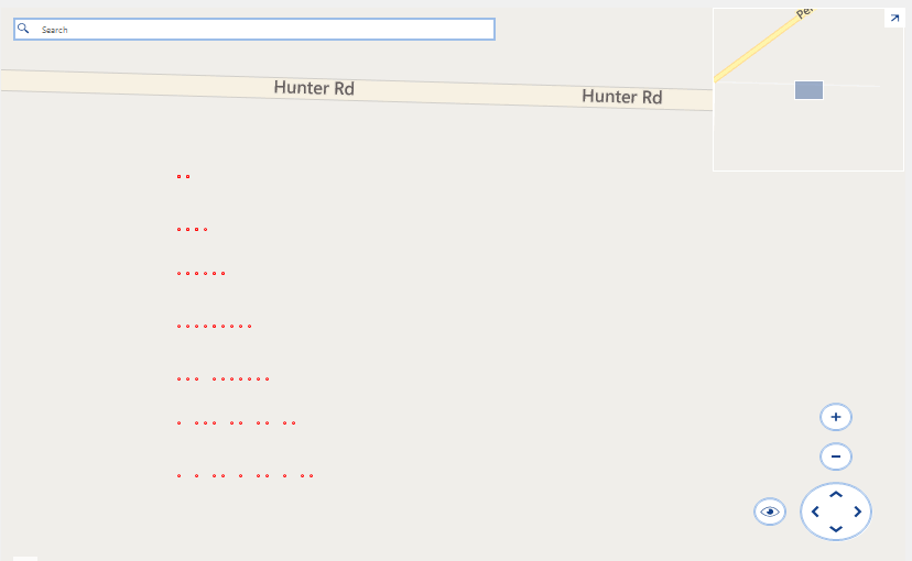
Run the attached project.
Expected:
10 points on each row.
Actual:
There is a seemingly random number of points on each row: